


Overlooking Cape Fear River from a bluff was Fort Johnston, the house that used to be until 2005 the fort commanders’ residence throughout its existence. A small museum describes in detail its former glory. This fort was built at the mouth of Cape Fear River in 1745-1754 to “protect the upriver settlements, dispatch river pilots, and provide quarantine. A small community of pilots, fishermen, and tradesmen grew up around the fort.”


Across the street from the former fort and the maritime museum is the beautiful Robert Ruark Inn, celebrating Robert Ruark, a prolific writer and famous native son of Wilmington and Southport. Sadly, he died quite young from liver cirrhosis, a significant loss to the literary world, but not before he gave us The Old Man and the Boy, among many other significant books.
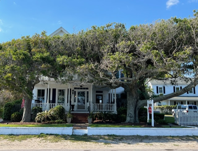
By the look of the expensive homes lining the shores, the population has changed drastically since the inception of Southport, although the influx of wealthy retirees from New York, New Jersey, Virginia, and Washington, D.C., have been encouraged to renovate older homes to keep up the historic charm of the old fishing village.
The town of Smithville was established
in 1792, named after one of North Carolina commissioners, Benjamin Smith,
who served under General Washington in the Revolutionary War. The patriotic
roots of what was to become later Southport, run deep. Smithville was a fishing
village and military town because Fort Johnston was involved in every U.S. war.

In 1808 Smithville became the county seat of Brunswick County but the seat was relocated to the town of Bolivia in 1978. In summertime Smithville became a popular resort – the climate was mild, and the sea breeze was pleasant. We experienced mild winds every day and sat on the benches lining the shore around the fishing pier, watching the river, the boats, and breathing in the salty air.
The effort in the 1880s by northern
businesses to transform Smithville into a southern port did not materialize,
except for the name. The little fishing village became known as Southport in
1887.

Because the town has celebrated Independence Day since 1795, it is listed in the National Register of Historic Places and hosts the official North Carolina 4th of July, Independence Day festivities.
Southport serviced river steamers
until 1925, a railroad from 1911 until World War II, and was connected by ferry to
Fort Fisher since 1966. The ride is quite inexpensive, $7, and beats driving to
Fort Fisher. I would not know what the ferry ride is like as my daughter gets seasick
and insisted on driving.

Southport’s river pilots spotted ships approaching the Cape Fear River entrance for over 250 years. Since 1751 when legislation regulated Cape Fear pilots, they have met ships in small crafts, guided them past treacherous shoals, then safely to port. Pilots knew a ship needed their help when it fired a cannon or a gun. An 80-foot tower served as a lookout. After climbing a ship’s Jacob’s ladder, the pilot took control of the ship until it reached port. Not only were river pilots’ services important to the Confederacy during the Civil War, but also during the Vietnam War. In one year, 1,200 ships were guided to the Military Ocean Terminal at Sunny Point, “the largest site for ammunitions transfer on the East Coast.”


Today Cape Fear River pilots still climb the Jacob’s ladder to guide ships through 21 turns on their way to Wilmington. Pilots say that the most difficult turn in the river is right off the Southport shoreline.

At the mouth of Cape Fear River are Bald Head Island and Oak Island. “Beyond the Cape for twenty miles are the Frying Pan Shoals, an underwater area named for the skillet-like shape of the shoals on older charts.”

Less than nine miles northeast along the coast is Fort Fisher, a Confederate fort during the American Civil War, protecting vital trading routes of the port in Wilmington, NC, from 1861 until its capture by the Union in 1865. Fort Fisher is located on one of Cape Fear River’s two outlets to the furious Atlantic Ocean on Federal/Confederate Point, known today as Pleasure Island.


The construction was accomplished with
sand-filled wheelbarrows pushed and pulled along gangways. "It was more labor
than the pyramids," Sgt. T. A. McNeill wrote to Mary Margaret McNeill on March
28, 1863. “We are building a mountain seventy-two feet high, I don’t think we
will ever get it done,” he lamented.
Apparently,
the battle of Fort Fisher was the most decisive battle of the Civil War fought
in North Carolina. According to museum archives, Lt. Joseph J. Scoggs, of the Fifth United States Colored Troops wrote, “After taking Fort Fisher, I think our
troops could storm Hell itself.”
Because
Fort Fisher was the largest fort protecting Cape Fear River, the Union Navy
focused a massive attack on December 23-27, 1864, and Fort Fisher fell on
January 15, 1865, following a second battle.


Not far from Fort Fisher is a beautiful beach and the aquarium with its unusual residents, the albino gator, Maverik, the golden eagle, rescued with a damaged wing, turtles, gators, sharks, and other aquatic creatures.

Oak Island shares the barrier island with Caswell Beach. It is located about 8.2 miles from Southport. Oak Island operates a greenhouse for sea oats and other native beach vegetation. Its Maritime Forest and sand dunes, especially along Caswell Beach Road, protect the town from wind and salt erosion, and the fauna and flora that lives within – the American toad, the Eastern Painted Bunting, reptiles such as copperhead, coral snake, pygmy rattlesnake, cottonmouth, green snake, corn snake, Eastern garter, black racer, deer, and small mammals. Loggerhead turtles use Caswell Beach as resting and nesting sanctuaries. Sea gulls and brown pelicans can be seen fishing in the surf.

The roots of the Maritime Forest, the beach grass, yucca, prickly pear cactus, Indian blanket, sea oats, and other wildflowers hold somewhat the ever-shifting dunes.

The entrance to the Cape Fear River was guarded by four lighthouses:
1. Prices Creek
2. Old Baldy – the oldest standing lighthouse in
North Carolina, 90 feet high, is an octagonal tower made of brick and plaster;
the original one was demolished in 1813 due to severe erosion.
3. Cape Fear Lighthouse – built of iron in 1901,
the 150-foot-tall tower was abandoned in 1958 when the automated light on
Oak Island was finished.
4. Oak Island Lighthouse – currently standing 153
feet tall, built of reinforced concrete, with no spiral staircase; a series of
metal ship ladders with 131 steps (rungs) lead to the gallery level; 70,000
candle power made this lighthouse the brightest in the U.S. and the second
brightest in the world, which can be seen for 16 nautical miles; today a 1,000
Watt halogen bulb generates 2.5 million candle power; the warning is composed
of 4 one-second flashes of light, followed by 6 seconds of blank.


Climbing into the Oak Island Lighthouse was out of the question for us but not much of a challenge for sailors, young adults, and teenagers. Next to the lighthouse is the U.S. Coast Guard Station. In 1874, the United States Life Saving Service was formed, the precursor of the U.S. Coast Guard which was established in 1915.

The first keeper was T. M. Savage of Smithville (Southport). A crew of nine, including six surf-men, manned the station from September through April. Rescues were attempted with a surfboat or a line-throwing gun, depending on oceanic conditions. Local fishermen were the surf-men and used a Lyle gun mounted on a carriage. From the edge of the surf, it fired a projectile attached to line if the wreck was within 500 yards of the beach. The line was secured to the wreck and each sailor was brought on this line to the shore, dangling over the ocean.
On the Eastern end of Oak Island, on a
site visited by the Fifth President of the United States, James Monroe on April
18, 1819, Fort Caswell was built in the 1830s. He visited both Oak Island and
Bald Head Island, calling the area, “the Atlantic frontier” because “the site
commands the mouth of the Cape Fear River.”
Named after the first U.S. Governor of
North Carolina, Richard Caswell, the fort’s construction started in 1827 and was
completed in 1838 on 2,800 acres purchased on Oak Island, at the time a “desolate
island.” Adjusted for inflation, the fort’s construction cost almost $12
million in 2021 dollars.
After the Civil War, the fort fell to disuse, but was used again during the Spanish-American War and World War I when
it was a post of the U.S. Army Coast Artillery Corps. Sold in 1925, the land
was operated as a summer resort. During World War II, the U.S. Navy purchased the
248.8 acres inside the sea wall for $75,000 from the Caswell-Carolina
Corporation.
In 1949 the Baptist State Convention
of North Carolina bought the property and is using it currently for Baptist
Youth camps and church retreats. I was utterly disappointed that we were not
allowed on the property or to see what remains of Fort Caswell; the entrance
was guarded by a young man.
Underwater archeologists have found an
estimated 5,000 shipwrecks in North Carolina's waters of which fewer than 1,000
have been exactly located and identified, among them the Agnes Fry and its
bell.
Agnes E. Fry was a blockade runner. During the Civil War, blockade runners were steam ships used
to get through the Union blockade extending 3,500 miles along the Atlantic and
Gulf of Mexico coastlines. The Confederate states, which had no industrial
capability, had to rely on imports from Scotland and England to provide the
arms and supplies needed to fight the Union.
Agnes E. Fry, initially called the Fox by its builder
in Scotland, renamed after Joseph Fry’s wife, tried to enter the river
steaming eastward along Oak Island but it ran aground on the Frying Pan Shoals
the evening of December 26, 1864. The surf and the sand eventually buried it.
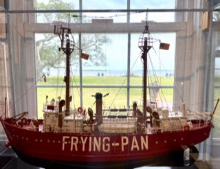
Another vessel, the Virginius, also commanded by Joseph Fry, sank in 1873, 11 miles from the wreck of the Fry and nine years to the day that the Fry sank.
One of the stops took us to beautiful Kure beach with its serious and thriving population of fishermen who call themselves the Misfits.

For me, the tranquil Caswell Beach with its dunes and maritime forest was a remarkable point in our visit. The best and most fascinating was the Airlie Gardens in Wilmington, a place where I could lose myself in the verdant and magical splendor.

.jpg)

Airlie Gardens represent “more than a century of gardens by the sea,” a place of reflection and solitude, surrounded by 67-acres of formal gardens, huge live oaks, sculptures, a church, wildlife, historic structures, views of Bradley Creek, the shade of ancient oaks, and a butterfly garden.


The Camellia Garden contains a vast collection of antique camellias and a 150-foot rose trellis.

The Lebanon Chapel was built in 1835 and was deeded to St. James Episcopal Church in Wilmington.

A mystery grave of an 18th century man named “John Hill” is found in the shaded gardens. According to legend, he was a marshal of Napoleon and a tutor.


The Pergola Garden, designed in the 1900s is built of tabby and covered in jasmine. A tiered fountain has steps leading into the lake.

The Butterfly House is a peaceful place of reflection, reading a good book, a protected habitat with metal sculptures, native butterflies, and plants.

The Bottle Chapel is constructed from 2,800 colored bottles, “celebrating the spirit of Minnie Evans.” Sculptures and mosaics created by local artists complete the garden. A truly magical place, the Airlie Gardens transported us to a place of beauty and tranquility despite the warmer day.

The last jewel in the crown of our Atlantic side Outer Banks was Myrtle Beach, SC. It was a beautiful beach, but the Atlantic Ocean was very agitated, cold, and the waters were brown.


NOTE: All photos are by Ileana Johnson except the black and white photo of the archive surfer with cork belt
As usual, Ileana delights us with many interesting historical snippets uncovered in her travels, this time in the Cape Fear River region.....thanks!
ReplyDeleteThank you, David, for your kind words.
Delete