Friday, October 21, 2022

Our Road Trip to New England (Part III)

We left Plymouth, MA to travel 40 miles in heavy traffic to Boston, MA. Our very expensive, ordinary hotel chain was in Cambridge, MA, close to the metro. This is what happens to prices in a metropolitan area that houses the famous Harvard and there is a game in town. There was a sea of orange on the metro and in Boston for that night’s game.

We wanted to follow the Freedom Trail from Boston Common around downtown Boston to the Navy shipyard, across the river to Charlestown, a considerable distance on foot, 2.5 miles (4 km) as the crow flies, following a red brick line marked in the pavement, the Freedom Trail. Unfortunately, the 2.5 miles turned into 9 miles, according to my Fitbit, as we had to navigate the crowds and the streets that never truly run in a straight line.

The red bricks or red paint on pavement starts in Boston Common, downtown Boston, not far from City Hall topped with its golden and highly glittering dome, to Bunker Hill Monument in Charlestown. The stops along the trail include ground markers, such as that for the Boston Massacre, three graveyards, notable churches and buildings, and a historic naval frigate.

The Freedom Trail route has been around since 1953, conceived and promoted by a local journalist in 1951. At the time, 40,000 visitors were visiting the trail annually. It spans sixteen historical sites of importance to the Revolutionary war but excludes the Boston Tea Party and the narrative about it or about the Liberty Tree. There is a separate museum in town dedicated to the Boston Tea Party which is not included on the Freedom Trail.

We were excited to be in the town that gave birth to the American Revolution and enabled the colonies to throw away the shackles of the English crown by protesting in the Boston harbor in the now famous Boston Tea Party.

Churches and the Old South Meeting House, the Old State House, and Paul Revere House charge a $5 admission. Boston National Historical Park and a few NGOs and foundations oversee the Freedom Trail.

On the first floor of Faneuil Hall there is a visitor’s center which documents the route. The sixteen sites along the Freedom Trail, from south to north, are:

-         


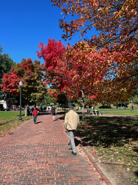
Boston Common (America’s oldest public park; it was beautifully enhanced by the fall foliage turning all shades of orange and magenta and the dogs and frisbees; this park had been used since 1635 for British militia training ground, public hangings, duels, public celebrations and public speeches)

-         


Massachusetts State House (completed in January 1798, at a cost of $133,333, five times the budget; the dome was originally wood, then Paul Revere & Sons was commissioned in 1802 to cover it in copper to prevent leakage, and finally gilded with 23-karat gold leaf in 1874; it is the oldest building on Beacon Hill and now the seat of Massachusetts state government)

-          Park Street Church (founded in 1809 and located on Brimstone Corner, a reference to fiery speeches but also the gun powder that was stored in the crypt during the war of 1812; My Country ‘Tis of Thee was first sung on the church steps)

-         


Granary Burying Ground (named so because of its proximity to Boston’s first granary; it is the resting place of many Bostonians such as John Hancock, Samuel Adams, eight governors, the five Boston Massacre victims, Paul Revere, Ben Franklin’s parents, Peter Faneuil, and allegedly the writer of Mother Goose)

-         


King’s Chapel and King’s Chapel Burying Ground (in 1686 King James II seized land and built the first Anglican church in the colonies; when the wooden structure proved too small for the congregation, a Georgian chapel was built around the original one; slaves sat in the rear gallery on the cemetery side of the chapel and condemned prisoners sat to the right before being hanged on the Common; King’s Chapel became the first Unitarian Church in America in 1785; governor’s pew was used by President Washington on his 1789 visit to Boston; the first cemetery is to the left of the chapel and contains graves of governors, William Dawes who also made the ride to Lexington with Paul Revere, the Mary Chilton, believed to be the first woman to step off the Mayflower)

-         


Boston Latin School site with the statue of Benjamin Franklin (embedded in the sidewalk is a plaque commemorating the site of the first public school in the U.S., 1635, in front of the old city hall; alumni of this school were Ben Franklin, John Hancock, Samuel Adams, Charles Bulfinch, and Ralph Waldo Emerson; the school still exists today, with four years of Latin still required; girls were not admitted until 1972)

-         


Old Corner Bookstore (the building used to be the home of Anne Hutchinson, banished from Boston in 1638 for her “unorthodox” religious views; became a literary center and a publishing house for many famous writers; the liberal Atlantic Monthly was originally published here;

-         


Old South Meeting House (second oldest church in Boston built in 1729; used for public meetings when “the angry crowds outgrew Faneuil Hall;” the most famous meeting was on December 16, 1773, when a crowd of 5,000 gathered to protest the tax on tea; it was the start of the Boston Tea Party; a notable member was the first black American published poet, Phillis Wheatley; her original work is on display)

-         


Old State House Museum (built in 1713, it is the oldest surviving public building in Boston, center for political and commercial life, similar to today’s Stock Exchange)

-         


Boston Massacre site (a ring of cobblestones adjacent to the Old State House commemorates the site where five men were killed in the clash between colonists and Redcoats)

-         


Faneuil Hall (meeting place and open-air market, a gift in 1742 by the wealthy merchant Peter Faneuil; all wars since 1812 have been debated here; it is nicknamed the Cradle of Liberty because of the impassionate speeches given here by Samuel Adams and James Otis; “it was here that Bostonians met to form their opposition to British authority;” women’s temperance movement and anti-slavery speeches took place here)

-         


Paul Revere House (built in 1680, 8 of his 16 children grew up in this home, his mother, his first wife, his second wife resided here; Revere started his midnight ride from here; he was an expert silversmith, a patriot, a copper manufacturer, engraver, and part-time dentist)

-         


Old North Church (Sexton Robert Newman hung two lanterns from this steeple on April 18, 1775, to signal that Paul Revere’s night ride began – it was considered the “spark that ignited the American Revolution;” this remarkable church is the oldest church building, with the first bells brought to the Colonies, the original eighteenth century brass chandeliers and clock, seventeenth century carved angels captured by a Colonial privateer; more than 1,000 people were laid to rest in the underground crypt)

-         


Copp’s Hill Burying Ground (largest colonial burying ground 10,000 plus since 1659, now only about 2,200 remain and the headstones have been moved from their location on the edge of all rows; Daniel Malcom, a member of the Sons of Liberty, Robert Newman, who hung the two lanterns are buried there and so is Edmund Hartt, the builder of the USS Constitution; being located on a bluff overlooking the Boston harbor, the British used the cemetery to aim their cannons on Charlestown during the Battle of Bunker Hill)

-          


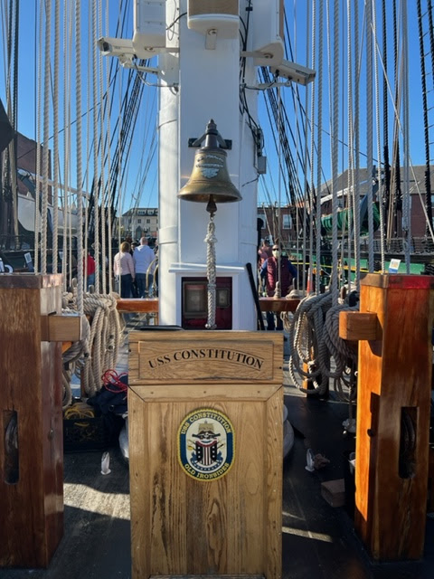
USS Constitution (Nicknamed Ironside because cannon balls would bounce off her impenetrable hull during the War of 1812, USS Constitution was launched in Boston in 1797; it is the oldest commissioned warship afloat in the world; every time a cannon ball would bounce off her hull, the seaman would yell Huzzah! Her sides are made of iron! Today the ship is manned by active duty U.S. Navy crew and docked in Charlestown Navy Yard)

-         


Bunker Hill Monument (A 221-foot obelisk commemorates the bloodiest battles of the American Revolution which took place on June 17, 1775; Don’t fire until you see the whites of their eyes was the battle cry of the ill-equipped Colonist soldiers)

On the beautiful morning we arrived by metro from Cambridge in Boston Common to start our Freedom Trail walk, a very large group of young people, dressed in strange outfits and offensive hats, were protesting in front of the Massachusetts State House for the “human right” to kill babies in the womb.

Boston Socialists had a booth in front of this protesting group, and they were accepting donations to their cause. The utterly confused girl, a Harvard student, manning the Boston Socialists booth attempted to tell me what kind of socialism they wanted – it was neither the socialism so many escaped from in Eastern Europe, nor the Scandinavian type of socialism many Americans believed to exist and salivated over everything free.  She was not quite sure what type they desired, and she listed a salad of things that we already have and had a hard time explaining, illustrating, or justifying her confused narrative. If she would have been in my class, I would have failed her.

I was truly overwhelmed and touched by the history surrounding us but, at the same time, I was shocked to see all the historical monuments and churches being defaced by Black Lives Matter posters and LGBTQ rainbow flags.

After we crossed the bridge, we made our way to the Charlestown Navy Yard to board the USS Constitution and the warship USS Cassin Young, a WWII era destroyer, decommissioned in 1960.  The sailors on board of both ships graciously described to visitors the different quarters and duties, while allowing us to go down all levels below deck.

After walking the Freedom Trail and downtown Boston all the way to Charlestown and Bunker Hill, we had covered 10 miles and we took the short ferry ride back to downtown Boston.


By the end of the day, we were so exhausted, we could not wait to get back to our hotel in Cambridge via the old and creaking green line metro with fascinating college student riders.

TO BE CONTINUED

Thursday, October 20, 2022

Our Road Trip to New England (Part II)

After visiting Fort Adam in Newport, RI and sitting on the dock, watching the sail boats race, I got on board the working ship called Oliver Hazard Perry, Rhode Island’s official flagship, a 200 ft. long ship with 20 sails, 7 miles of rigging, which had been commissioned in 2015. The guide told me that the battle against the salty water is a constant companion. Everything looked freshly painted and corrosion free, at least above the water.

There were anglers on the dock, spinning their tall tales, drinking beer, fishing for sport, catching mostly black sea bass, and throwing it back into the ocean.

We were hungry so we went looking for a parking spot for Flo’s Shack. Highly recommended, the seafood was delicious, generous portions for starving patrons, and the windows gave us a lovely view of the mostly deserted Newport, RI public beach. The tropical motif shack had a constant flow of locals coming to pick up their orders. The tourists were slim as the beach was deserted and the water very cold even for die-hard ocean bathers like us.


The history of Flo’s Shack is quite storied, like the fishermen’s tales on the dock. Given the proximity to the ocean, right across the busy road running alongside the beach, the restaurant had been destroyed three different times by hurricanes and rebuilt anew with a beautiful aquarium, three stories, bamboos alongside the exterior ramp, beach related memorabilia, and other interesting knick-knacks like the floating devices from various sunken ships.

Flo's Shack in Newport, RI

Newport Harbor, RI

Finally, the sun came out the next morning and the road took us 87 miles to Cape Cod, Massachusetts. The glossy brochures advertising Cape Cod were exaggerating the friendliness of the people and the beauty of the place by many degrees. I found New Englanders oddly unfriendly, but none as snobbish and cold as the people in Massachusetts.

I have a problem when people in general look down and sideways as they speak to me. I do believe that the eyes are windows to one’s soul. In my experience growing up under communism, people did not smile, greet other people kindly, hid their feelings, and made no eye contact with strangers or any interlocutor for fear that they might be arrested for talking to the “wrong people,” or for other trumped-up reasons the government might conjure up.

We woke up early to take the ferry to Martha’s Vineyard along with the many buses of tourists who filled the hotel after we arrived, all excited to see how the wealthy people live, the same affluent locals who recently rejected 50 illegal economic migrants off their island mere hours after their arrival.

Lucky for us, we missed the earlier 35-minute ferry from Cape Cod via Nantucket Sound to Martha’s Vineyard and a later ferry would have trapped us on Martha’s Vineyard all day with nothing to do or see. So, we decided to drive on to Plymouth, MA instead, a mere 45 miles west. There is a lot more history there to learn about our country.

Plymouth, Massachusetts is the place known as “America’s Hometown,’ because of its importance in American history and culture. I found it unusual that it was spelled in brochures and in museum Plimouth even though it was named after the English town, Plymouth. Much of what we know about the Plymouth Colony, including the odd spelling, comes from Governor William Bradford’s Of Plimoth Plantation. Spelling was not standard in the 17th century, and he used Plimoth a lot in his writings.

The day was sunny and balmy, and we made our way to Patuxent, the Indigenous name of the place where the Mayflower passengers settled their town. In the Wampanoag language Patuxent means “place of running water,” referring to the beautiful Town Brook which we walked along from the village to the location of the rock and Mayflower II in the harbor.


Patuxent homesite


The historic Patuxent homesite offered a fascinating view into the culture and habits of the Indigenous Wampanoag; how to make a wetu (a domed hut) and a canoe fashioned by the burning for 7-10 days of a fresh pine log (mishoon); and how the Wampanoag sunk their canoes in winter to preserve them from drying out and rotting.


A replica of the 17th century English village, which was originally located on first street downtown, had been built on the summer property of a wealthy local who liked archeology and kept finding evidence of the pilgrims, so he decided to recreate that village as it had been in 1627.

The English colonists were referred to as pilgrims because, when Governor Bradford recorded his community’s departure from Leiden, Holland, to America, he wrote, “they knew they were pilgrims.”


The 1636 grist mill of Plymouth Colony has been reproduced in modern times to demonstrate how the colonists harnessed the power of the Town Brook to grind corn. I bought cornmeal ground here from blue corn (also known as Hopi maize) and I cooked polenta, which turned out a lovely shade of lavender and it was quite delicious.

Blue corn has 20-30% more nutritional value than yellow or white corn, a lower glycemic index, is gluten-free, and has quite a few anti-inflammatory properties via anthocyanins.


Walking along the lovely Town Brook for about a mile, we arrived at Pilgrim Memorial State Park which displays the Mayflower II and the Plymouth Rock.


Tradition says that pilgrims stepped off the boat onto the rock. But neither William Bradford nor Edward Winslow, the main chroniclers of the colonists, refer to a rock in their historical accounts.


Perhaps the Rock was underneath a landing pier of sorts, or the shallop was moored to it. A shallop was a small landing vessel kept dismantled on Mayflower. The passengers were forced to sleep on the dismantled parts during the voyage and, once they reached their destination, it took 17 days to assemble it.


The rock was not identified as a landing place until 1741 by Thomas Faunce, a 95-year-old Elder in the First Church. How good was his memory? It depends on who you ask. As Rose T. Briggs said in Plymouth Rock: History and Significance in 1968, “It is the fact that they landed – and remained – that matters, not where they landed. Yet it is not bad thing for a nation to be founded on a rock.”

The Plymouth Rock was placed beneath a portico built in 1921 in Neo-Classical Revival style, 300 years after the pilgrims’ arrival. The rock, real or imagined, had an interesting history:

-         News in 1741 that the rock might be buried in preparation of the shoreline for the construction of a wharf, prompted citizens to defend it

-         Thomas Faunce, 95-years old, said that it was THE landing rock (he knew it because he knew some of the original pilgrims; how that was possible when it had happened 120 years before)

-         The top half of the rock was moved to Town Square in 1774 with the help of 30 oxen as a monument to liberty

-         July 4, 1834, the top half of the rock was moved again to Pilgrim Hall on Court Street

-         1867 the bottom half was trimmed to fit within the Gothic style granite canopy

-         1921 a new portico was built over Plymouth Rock

-         1970 the Plymouth Rock and the portico were listed in the National Register of Historic Places

-         If the pilgrims truly saw the rock when they landed, the rock would have been three times the size that it is today.


The Plymouth harbor is home to Mayflower II, a full-scale reproduction of the ship that carried the English colonists to the New World shores. Even though it is just a reproduction, it was a sight that took my breath away.

Mayflower II - reconstruction of the original Mayflower

There are no images or plans in existence of the original Mayflower, however, Mayflower II was built by hand, using the same tools from that period, combining information from period shipbuilding manuals and descriptions of Mayflower in primary sources.

The finished Mayflower II crossed the Atlantic in 1957, as a gift from England to the people of the United States. It has to be constantly kept in sailing condition and protected from the corrosion of the ocean.

According to the museum archives, “The original Mayflower left New Plymouth in early April 1621, returned to London a month later and, based on primary source evidence, was likely broken up and sold for scrap around 1624.”

The Mayflower carried its passengers (mostly reformed Christians fleeing the Church of England) and crew in the fall of 1620 on a 66-day harrowing voyage across the stormy and cold Atlantic Ocean. Seeing the cramped interior of the cargo area, I wondered how many souls could survive at sea in such conditions. On November 11, Mayflower dropped anchor in today’s Provincetown Harbor.

The ship was not built for passengers and the pilgrims had to sleep below deck on top of the cargo and on top of the dismantled landing boat. They were not allowed on the main deck except to dump their waste buckets overboard.

According to the museum archives, after weeks of searching for a suitable place to build a colony, the pilgrims arrived in Plymouth Harbor. “This was the site of the Wampanoag community of Patuxent, left uninhabited after a devastating epidemic that swept coastal New England just before Mayflower arrived.”

TO BE CONTINUED

The Six Banks' Alliance with the U.N. Must Be Stopped!

The Attorney General of Missouri, Eric Schmidt, who is running for Senate, in conjunction with Attorney Generals of Virginia and 17 other states are going after six major banks in the U.S. for their role in the alliance with U.N. in implementing ESG Zero Emissions by 2050.

This alliance assures that these six banks that hold 40% of banking assets in the U.S. will not give loans to agriculture (farmers), fossil fuel exploration (oil and natural gas leases and refining, and coal), manufacturing, destroying the U.S. economy and whatever jobs are left in order to satisfy a "woke" agenda of global communism by using the global warming narrative now turned into climate change agenda as an excuse.

This will destroy our sovereignty in perpetuity.

These "banksters" must be stopped.

U.N. derives most of its money from the Unites States, from us, the taxpayers.

Wake up! We are going to lose everything!


Monday, October 17, 2022

Our Road Trip to New England (Part I)

The self-organized and guided road trip of a lifetime was enabled by hurricane Ian which canceled our trip to Florida. We were looking forward to vegging on the beach, reading, swatting the occasional fly, and splashing in the ocean in hopes that no shark or sting ray found us interesting enough to take a bite or a stab.

We decided instead to see that part of America which gave us the imagined and real freedoms we think we have today – New England. What better way to celebrate our country than visit the Freedom Trail in Boston, MA?

To accomplish this, hubby chose a road route that will force him to drive almost 1,700 miles across twelve states on our way to New England’s states, Connecticut, Massachusetts, Rhode Island, New Hampshire, Maine, and Vermont.

New England is made up of six states: Connecticut, Rhode Island, Massachusetts, New Hampshire, Maine, and Vermont. The New England region is in the upper northeast corner of the lower 48 United States, and bordered by New York, Canada, and the Atlantic Ocean. 

After crossing through Virginia, Maryland, Pennsylvania, Delaware, New Jersey, and New York, the first stop was in New Haven, Connecticut. It was a drizzly rain kind of day, cold for us southerners, but a regular fall day for New England.

The roads and streets wore a patina of old mixed with litter and fallen leaves. We found the beach, bleary, with a carpet of broken seashells gently bathed by the greenish dark waters of the Atlantic. A few sea gulls were resting on the dark sand. There was no match here for the beautiful white sands on the western Florida’s beaches. A lone tree was dripping rain onto a bench looking over the bay.

We were hungry so we made our way to a beach shack where delicious smells were wafting in the salty air. But the outdoor seating drove us away when it started to rain in earnest. So, we decided to go downtown and find a more suitable place where we could take shelter inside from the rain and soggy cold.

Interior of Luis Lunch with the church pews

Luis Lunch in New Heaven, CT

We found a tiny building, Louis Lunch, lit up and welcoming like a fairy tale ginger house in the urban grey forest. The restaurant claimed to be the first place in America that invented hamburgers in 1895, and this hamburger was served on toast.

A sign inside stated, I paraphrase, this is not fast food, we serve our burgers the way we make them. A tall guy behind the counter wearing a mask took our order. He was curt and nobody could think of him as the owner of a sociable temperament.

As we learned every day, New Englanders were not friendly and welcoming even when spoken to. When talking, they always looked down or sideways, never in the interlocutor’s eyes. When we got to coastal Maine, it was night and day, people were friendly and welcoming.

We sat down inside Luis Lunch in the church pews which were now serving as chairs and ate our interesting burgers and potato salad served in Styrofoam cups. I thought New Englanders were all about saving the environment as the signs told us so in all six states.

Mark Twain's home in Hartford, CT

Harriet B. Stowe's home in Hartford, CT

A quick stroll on the Yale campus was disappointing and we headed next morning to Hartford, CT, in a drizzly rain – to the homes of Mark Twain and Harriet B. Stowe. Mark Twain was my favorite author growing up. His characters were hilarious even in Romanian translation which I am sure, it was no easy feat to interpret correctly.

On the road to Mystic, CT, we stopped in East Haddam and Lyme, CT, where we found the retirement home of actor William H. Gillette (1853-1937), his rock “castle,” a 122-acre estate that sits on top of a hill known as the Seven Sisters, on the banks of the Connecticut River.

Gillette's rock "castle"

This estate, in his heyday, had its own miniature 3-mile railroad which stopped to pick up private visitors to the castle at his own Grand Central Station and other locations along the way. A short portion of the track and the locomotive stored in the museum, are the only remnants of Gillette’s private railway.

Gillette's train station

Walkup to the Gillette's rock 'castle'

Gillette house solarium

Gillette’s twenty-four room mansion resembled a medieval castle and was built in 1914. It looks like a ruin from the exterior, but it is just weathered stone. William Gillette was an actor, manager, playwright, and railroad enthusiast born in Hartford, CT. He is best remembered for his portrayal of Sherlock Homes on stage in both America and Europe, wearing the legendary hat and pipe. He also played in a 1916 silent film which was considered lost until it was rediscovered in 2014.

Heavy rain had followed us from Virginia to New York, but in Connecticut it was misty and drizzly, mixed with heavy rain that did not last long. It reminded me of the ten-day rain we experienced in Paris years ago – everything was damp and so cold.

Dinosaur park

My husband joked that he would stop if he found the world’s largest ball of twine. Instead, we stopped for a huge dinosaur resplendent with a witch’s hat. It was a fascinating trading post for fossils, crystals, and minerals. The associate was very talkative and knowledgeable – he was from Montana and had just moved to Connecticut.

Mystic River

Mystic River Bascule Bridge

Mystic Village

Mystic is a lovely village with no independent government, located in Groton and Stonington, CT, on the Mystic River which flows into Fishers Island Sound and by extension Long Island Sound and the Atlantic Ocean. In its seaport, more than 600 ships were built over 135 years, starting in 1784. Mystic is home to the Mystic Seaport, one of the largest maritime museums in the U.S., preserving many sailing ships and the whaler Charles W. Morgan. In the center of the village there is a drawbridge that is activated like an elevator, with counterweights – it is called the Mystic River Bascule Bridge.

Mystic Pizza in Mystic, CT

Mystic Pizza is the location where the 1988 movie by the same name was filmed. It is a quaint and beautiful village populated by 4,205 die-hard New Englanders. The name Mystic is derived from the Pequot term “missi-tuk,” describing a large river whose waters are driven into waves by tides or wind.

Cliff Walk in Newport, RI

Next stop was Newport, Rhode Island. Early in the morning, we walked to the 3.5-mile Cliff Walk, wrapping around the many Gilded Age mansions overlooking the Narragansett Bay, oceanic waters breaking furiously into a white foam over the black cliffs with unimaginable power.

Newport is a seaside city on Aquidneck Island in Newport County, Rhode Island. Like most New England locations, place names were given in Native American to honor the tribes who had inhabited the geographic area. The sad thing is that nobody can pronounce the names.

Long view of the Cliff Walk in Newport, Rhode Island

Located 74 miles south of Boston, Newport is known as New England’s summer resort for the rich and famous and for its sailing history.

Vanderbilt interior

Mansion donated to the Salve Regina University

Among the many beautiful seaside mansions, some of which were donated to the Salve Regina University campus, the most notable was the Vanderbilt Mansion Museum, The Breakers, a classic Italian palazzo, which is open to the public and a major attraction for tourists arriving in huge Pullman buses. It has entertained royalty, presidents, and the famous over many decades of its original history. 

Vanderbilt mansion terrace

Built in 1893-1895, to replace a smaller wooden structure destroyed by fire, The Breakers was built in Italian Renaissance style with opulent 50 ft. atrium ceiling, an entire acre of the 13-acre property with 70 rooms, including 48 bedrooms for family, guests, and staff, with 27 fireplaces and electricity, a novelty for the Gilded Age, and gas lighting.

The Breakers

Cornelius Vanderbilt II, one of the richest millionaires of his time, and his wife Alice chose such a structure of steel, brick, and limestone with boilers underground to prevent another potential fire. In the Vanderbilts’ summer home, the opulence is evident in the rich interior marble, gold leafing, platinum leafing, tapestries, fireplaces, music room, coffered ceilings, draperies, Gilded Age furniture, chandeliers of Baccarat crystal, mosaics, and the massive tub carved out of one block of marble for Cornelius. Nobody anticipated that the servants had to fill and empty the tub four times each time before the water would be warm enough for Cornelius to bathe in.

Back patio of the Breakers overlooking the Atlantic Ocean


The Breakers Music Room

Spending money lavishly, faster than it could be replaced, the Vanderbilts blew through the original fortune and Countess Szechenyi, the heir, was forced in 1948 to accept $1 and coverage of the operating expenses by the Preservation Society of Newport County, to offer tours of the first floor to the public. According to the archives, the mansion and property were purchased in 1972 by the Preservation Society from the heirs for $399,000. In 1994, it became a National Historic Landmark. The architect Richard Morris Hunt had created a Gilded Age jewel of opulence and beauty which ordinary people can now visit and admire.

TO BE CONTINUED